 Thursday I thought with the third day of sun, maybe things were returning to normal, however watching the local news at night, I know that’s far from the truth. I’m sitting here stunned. But given the report that the Memphis/Shelby County Emergency Management Agency (MSCEMA) will be issuing new map tomorrow morning, I’m going to wait to post this then, but I am going to go ahead and write most of this while my mind is trying to process the news so I don’t forget things.
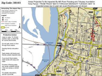
UPDATE: The maps are incredibly detailed this round. Very clearly showing that most of Memphis has a low possibility of flooding. HOWEVER, I encourage folks to look at the maps ans see if you or a member of your family are possibly or likely to flood. I’d suggest getting people, precious items, & pets out of those homes marked in red starting now. No need to risk your safety and the safety of others. Here’s one of the maps I reviewed and it links to the site where the other maps can be found.
Quick Situation Overview
Water Levels in a Few Key Locations
- At Memphis, Friday morning’s water level at 7 a.m. is forecast to be 45.8 feet and the major flood stage is 46 feet. Its anticipated to crest at 48 feet next Wednesday, May 12.
- Wolf River in Germantown was anticipated to be receding from 11.18 feet to 10.18this morning.
- The Loosahatchie in Arlington appears to still be rising, and rising quickly. On Thursday it was 3.81 feet and is anticipated to be at 8.7 feet Friday morning.
- At Osceola, AR, Friday morning’s water level at 7 a.m. is forecast to be 46.1 feet.
- At Caruthersville, MO, Friday morning’s water level at 7 a.m. is forecast to be 47.8 feet.
A flood warning has been issued for all of Shelby County. At this time none of my family is being evacuated but the list does include some of our zip codes. We will be studying maps closely to determine whether our safety will be jeopardized. The new maps include more detail including landmarks. Than the ones previously used in hopes to gain clarity about which exact areas are impacted. Looking at the previous set of maps, my family was not in an evacuation zone so I’m hoping the new one clarifies that for us & we all get to stay put safe & dry in our homes. If MSCEMA, we will certainly take recommended steps to get to safety. Evacuations are expected to impact 20,000 people here.
Evacuations
- Some areas of north & south Memphis have already undergone voluntary evacuation. Plenty of people are saying never here and we all need to know it could be here. Evacuations are preferable to rescues which may not be as timely. People who already have water around their house should prepare for evacuation (Memphis/Shelby County Emergency Management has a great list of things to take with you, things to do at home, key contacts, etc.)
- The Memphis Police Department has cancelled all time off for officers who will be working around the clock to evacuate the people impacted. There are reports that bogus warnings of evacuations in some neighborhoods where flooding has already begun has some residents worried. There are some home owners who are choosing to stay despite the need to drive through water. With that in mind, the evacuations will be carefully coordinated to insure people and property are protected as much as possible.
- Other cities & towns which have been mentioned to be evacuating include Identification is required for entry into some areas of the town. Dyersburg, Tennessee due to the levels of the Forked Deer River. West Memphis, Arkansas is looking at what impacts they may need to prepare for. Earle, Arkansas which has had waist high water since Monday but water is reportedly going down. A farmer in the area says they’ll be okay as long as the Mississippi River levee holds
 Info for Locals
- City Crew Adding Flood Gates — Memphis has flood gates in several areas (in fact, the flood gates at Riverside & Beale are already backing water out onto the street). The first 16 gates were to be able to handle a 48 and the two new ones should handle up to 50 feet. Additional gates are available and will be used as needed.
- Sandbagging Volunteers Needed — The downtown area has some differences in how high areas are. Some of the major parts of town are quite high and others are lower. The Pinch District is one of the lower areas and for this reason, volunteers are urged to help fill & place sandbags. Volunteers can go to the Memphis Pyramid from 9 am to 6 pm on Friday. (Family friend Cindy Wolff is photographed at right, she wrote this great article for today’s paper… now I think I need to take the afternoon off to volunteer.)
- The website https://www.staysafeshelby.us/ pulls together news and information from the Shelby County Office of Preparedness and lists things like river levels, etc.
- A new cross functional command center will be set up in the Raleigh Springs Mall.
- Creation of a tent city to house evacuees is also underway.
- A big ooops…. The DeWitt Spain Airport is flooded by a private crew puncturing a water main when attempting to build a levee. The water is safe though.
- Water moccasins are just one of the things you could find in flood water. Be careful!
Resources for Travelers
- Road Closures — Last spring in the day or two before I headed to the Kingston Springs area that had been devastated by flooding, I discovered the TDOT SmartMap. It is awesome! You can select road conditions for the city of Memphis or on a county-wide basis. For smaller, city roads, in Memphis & Shelby County, check the MSCEMA site for a list of closures. The Arkansas Highway and Transportation Department also has a mapping system and text versions accessible online.
- Interstate Closure — 1-40 near the White River between Little Rock & Memphis is closed. The detour takes 120 miles of regional roads for people to get between the two cities. They hope to open it Monday as the White River recedes.
- Reduced River Access in Memphis — Tom Lee Park was closed (and the section of Riverside drive going through there from Georgia to Beale) when I was downtown (see photos of my Tuesday visit here). The fencing, etc for Memphis in May is still in place and access is limited to the park. Due to the water already in Mud-Island & Harbor Town, Memphis Police have closed the area. It is only open to residents and media with the proper credentials.


[…] advocacy ← New Warnings in Memphis Regarding Flooding and Evacuations […]